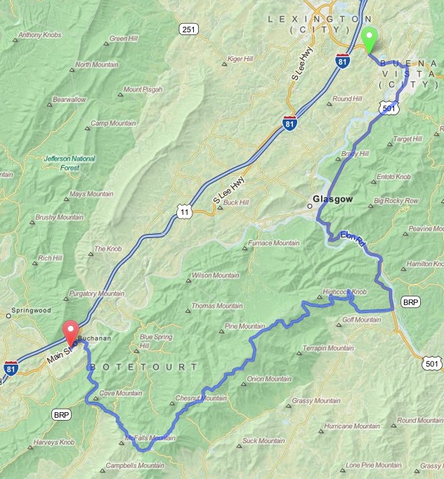
Buena Vista to Buchanan - Virginia
Distance: 53 Miles Duration: 1 Hour 25 Minutes
Data, imagery and map information provided by MapQuest, Open Street Map and contributors, CC-BY-SA,.
Please note that this route has roads that may be seasonally closed.
Please check that these roads are open before planning your trip.
|
Starting Point: Intersection of Alpine Dr and US-60 E/E Midland Trail
1. Head southeast on US-60 E/E Midland Trail toward Chicory Ln 2. Turn right onto Vista Links Drive 3. Turn left onto W 10th St 4. Turn right onto 10th St 5. Turn left onto W 10th St/Paxton Dr/State Route 745 6. Turn right onto Maury River Rd 7. Continue onto W 10th St 8. Turn right onto US-501 S/Magnolia Ave 9. Turn right to stay on US-501 S 10. Turn right toward Blue Ridge Pkwy 11. Continue straight onto Blue Ridge Pkwy (This road may be seasonally closed) 12. Merge onto VA-43 N/Parkway Dr via the ramp to Buchanan (This road may be seasonally closed) 13. Continue onto Lowe St 14. End Route |
1.3 Miles 0.9 Miles 0.5 Miles 0.2 Miles 0.2 Miles 0.2 Miles 0.3 Miles 14.2 Miles 3.2 Miles 0.2 Miles 26.8 Miles 4.8 Miles 0.5 Miles |
Other Cities or Towns that this Route passes through:
Glasgow, VA
Glasgow, VA
Directions from scenicdriver.com are only to be used for planning purposes. It is possible that traffic, weather, construction projects or other events may cause conditions to differ from the directions listed and the map image shown, please plan your route accordingly. All signs or notices regarding your route must be obeyed.
