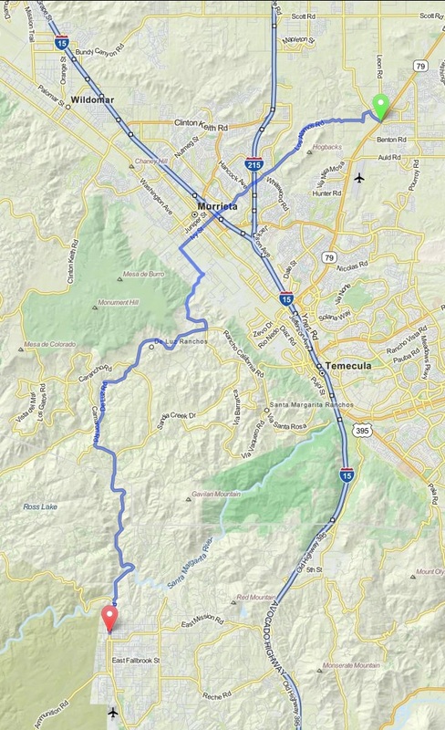
Murrieta to Fallbrook - California
Distance: 24 Miles Duration: 57 Minutes
Data, imagery and map information provided by MapQuest, Open Street Map and contributors, CC-BY-SA,.
|
Starting Point: Intersection of Max Gillis Blvd and Winchester Rd
1. Head northwest on Max Gillis Blvd toward Brown Bear Dr 2. Take the 2nd left onto Leon Rd 3. Turn left onto Briggs Rd 4. Turn right onto Los Alamos Rd 5. Continue onto Ivy St 6. Turn left onto Hayes Ave 7. Turn right onto De Luz Rd 8. Take the 2nd right to stay on De Luz Rd 9. Take the 1st left onto Cll Capistrano 10. Take the 3rd right onto Rancho California Rd 11. Slight left onto De Luz Rd 12. Turn left onto Camaron Rd 13. Take the 1st left onto De Anza Rd 14. Turn right onto Sandia Creek Dr 15. Turn right to stay on Sandia Creek Dr 16. Continue straight onto De Luz Rd |
0.4 Miles 0.2 Miles 0.2 Miles 5.8 Miles 1.0 Miles 1.0 Miles 1.0 Miles 0.5 Miles 0.8 Miles 0.8 Miles 4.5 Miles 0.6 Miles 0.7 Miles 4.0 Miles 1.3 Miles 1.0 Miles |
Directions from scenicdriver.com are only to be used for planning purposes. It is possible that traffic, weather, construction projects or other events may cause conditions to differ from the directions listed and the map image shown, please plan your route accordingly. All signs or notices regarding your route must be obeyed.
