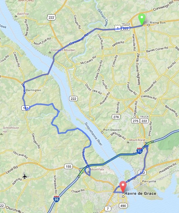
Rising Sun to Havre de Grace - Maryland
Distance: 27.6 Miles Duration: 57 Minutes
Data, imagery and map information provided by MapQuest, Open Street Map and contributors, CC-BY-SA,.
|
Please note that this route has tolls.
Starting Point: Intersection of W Main St/MD-273 W and Harrington Dr 1. Head west on W Main St 2. Continue onto MD-273 W/Rising Sun Rd 3. At traffic circle, stay straight to stay on MD-273 W/Rising Sun Rd 4. Turn right toward U.S. 1 S/Conowingo Rd 5. Turn left onto U.S. 1 S/Conowingo Rd 6. Turn left onto MD-161 S/Castleton Rd 7. Turn left onto MD-161 S/5th Ave 8. Slight left onto Shuresville Rd 9. Continue onto Stafford Rd 10. Turn right onto Craigs Corner Rd 11. Take the 1st left to stay on Craigs Corner Rd 12. Turn right to stay on Craigs Corner Rd 13. Take the 1st left onto Wilkinson Rd 14. Turn left onto Rock Run Rd 15. Turn right onto Stafford Rd 16. Take the 1st right onto Lapidum Rd 17. Turn right onto MD-155 W/Level Rd 18. Take I-95 N/JFK Hwy ramp to New York N (Toll road) 19. Merge onto I-95 N (Partial toll road) 20. Take exit 93 for MD-222 toward Perryville/Port Deposit 21. Turn left onto MD-222 S/Perrylawn Dr 22. Slight right onto US-40 W 23. Turn left onto Otsego St 24. Turn right onto N Union Ave 25. End Route |
89 Feet 0.5 Miles 0.6 Miles 348 Feet 7.4 Miles 0.2 Miles 0.5 Miles 0.4 Miles 2.2 Miles 0.5 Miles 1.0 Miles 0.3 Miles 1.1 Miles 0.2 Miles 1.1 Miles 2.4 Miles 0.2 Miles 0.5 Miles 3.9 Miles 0.3 Miles 1.6 Miles 2.1 Miles 0.5 Miles 299 Feet |
Other Cities or Towns that this Route passes through:
Darlington, MD
Perryville, MD
Susquehanna State Park
Darlington, MD
Perryville, MD
Susquehanna State Park
Directions from scenicdriver.com are only to be used for planning purposes. It is possible that traffic, weather, construction projects or other events may cause conditions to differ from the directions listed and the map image shown, please plan your route accordingly. All signs or notices regarding your route must be obeyed.
