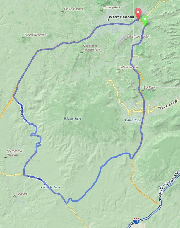
Sedona to Cornville (Loop)
Distance: 44 Miles Duration: 1 Hour, 25 Minutes
Data, imagery and map information provided by MapQuest, Open Street Map and contributors, CC-BY-SA,.
Description
This is a loop route that goes from Sedona to Cornville and back. You can get some great views of canyons and mountains in the distance as you start your trek down Highway 179. As you approach Valley of Oak Creek you will get very close views of some breathtaking rocky mountains. Beaverhead Flats Road and Forest 119 Road offer up some nice wide open views of the desert and it's terrain.
Page Springs Road takes you up through some canyons and trees which can be very green in the spring time. Towards the end of this route you will turn in to Red Rock Loop Road which will take you up to Red Rock State Park for more amazing views of the rocky mountains in the area.
Page Springs Road takes you up through some canyons and trees which can be very green in the spring time. Towards the end of this route you will turn in to Red Rock Loop Road which will take you up to Red Rock State Park for more amazing views of the rocky mountains in the area.
Directions
Starting point: Intersection of HWY AZ-179S and Ranger Road
1. Head south on Hwy 179 S
0.2 Miles
2. At the traffic circles, continue straight to stay on AZ-179 S
9.9 Miles
3. Turn right onto Beaverhead Flats Rd
6.1 Miles
4. Turn right onto E Cornville Rd/Forest 119 Rd
3.6 Miles
5. Turn right onto S Page Springs Rd
7.3 mi
6. Turn right onto Arizona 89A N/N Page Springs Rd
5.8 mi
7. Turn right onto Red Rock Loop Rd
3.9 mi
8. Slight left onto Red Rock Loop Rd/Upper Red Rock Loop Rd
Continue to follow Upper Red Rock Loop Rd
3.1 mi
9. Turn right onto Arizona 89A N
4.0 mi
End Route
Other Cities or Towns that this Route passes through:
Village of Oak Creek, AZ
Red Rock State Park
Directions from scenicdriver.com are only to be used for planning purposes. It is possible that traffic, weather, construction projects or other events may cause conditions to differ from the directions listed and the map image shown, please plan your route accordingly. All signs or notices regarding your route must be obeyed.
