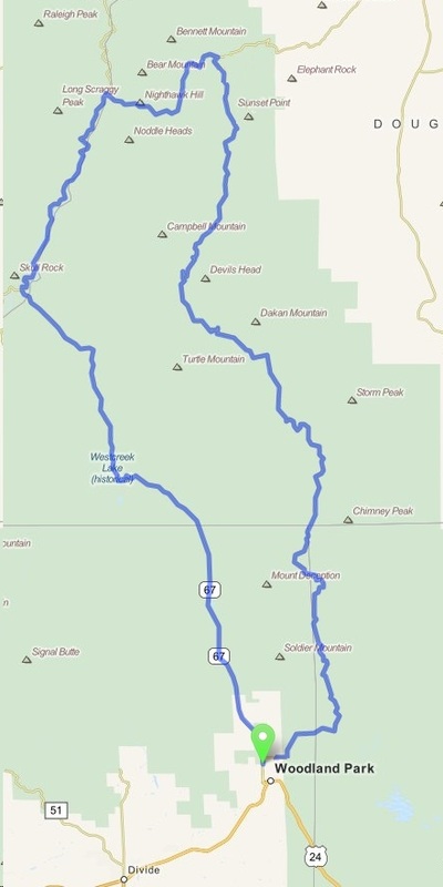
Woodland Park - CO 67 (Loop)
Distance: 76.6 Miles Duration: 3 Hour, 9 Minutes
Data, imagery and map information provided by MapQuest, Open Street Map and contributors, CC-BY-SA,.
Directions
|
This is a loop route that goes around an area of the Pike National Forest.
1. Head north on CO-67 N 2. Continue onto Co Rd 97/S Platte River Rd 3. Turn right onto W Pine Creek Rd 4. Continue onto CO-67 N/S Co Hwy 67 5. Head north on CO-67 N/Pine Creek Rd 6. Turn right onto Rampart Range Rd 7. Turn right onto S Rampart Range Rd 8. Turn left to stay on S Rampart Range Rd 9. Head east on Rampart Range Rd 10. Continue onto Co Rd 22 11. Turn right onto E Kelly Rd 12. E Kelly Rd connects back to CO-67 13. End Route |
27.4 Miles 4.5 Miles 3.1 Miles 1.6 Miles 1.7 Miles 8.9 Miles 14.0 Miles 3.8 Miles 8.9 Miles 1.6 Miles 0.9 Miles |
Other Cities or Towns that this Route passes through:
Pike National Forest
Pike National Forest
Directions from scenicdriver.com are only to be used for planning purposes. It is possible that traffic, weather, construction projects or other events may cause conditions to differ from the directions listed and the map image shown, please plan your route accordingly. All signs or notices regarding your route must be obeyed.
